
Tsunami Risk Evaluation and Management
Large tsunamis are natural phenomena that, despite their relatively low frequency, can cause significant damage, having impacted more than 400,000 victims in the last 150 years.
As was evident in the events that occurred in the Indian Ocean in 2004 and Japan in 2011, it is common to think that there is no way to mitigate their consequences. However, there are strategies aimed at preventing a natural phenomenon like this from becoming a natural disaster.
At IHCantabria we develop projects and tools precisely aimed at mitigating its impacts.
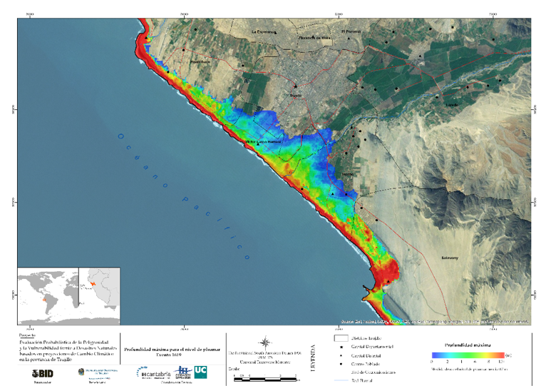
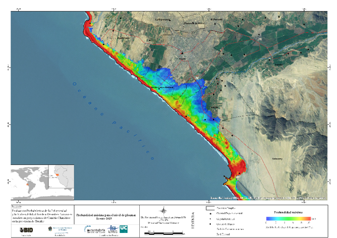
Maximum depth for the high tide level for the 1619 tsunami in Trujillo (Peru)
Methodology
We identify and characterize the coastal areas prone to tsunamis.
To do this, at IHCantabria we analyze potential tsunami generation sources, studies the generation process and calculates and assesses its impact on the coast. This analysis is carried out by applying numerical models that simulate the processes associated with tsunamis (generation, propagation and flooding), as well as through physical modeling (laboratory experiments), using the Wave-Current-Tsunami Flume [COCOTSU] at the IHCantabria facilities.
We analyze and characterize the exposure and vulnerability of existing natural and socio-economic systems in the potentially affected area, from a population-centered point of view.
We propose, develop and implement mitigation measures that reduce the risk from the potential impacts of a tsunami. These measures can range from generating risk and evacuation maps, to implementing early warning systems or awareness campaigns for the population. To this end, we work in close collaboration with the government agencies and local communities of each country where these measures are implemented.
We train technicians and specialists in disaster management, as well as the researchers who develop new methodologies and tools, which are then transferred to society. The Institute has also trained experts in countries such as El Salvador, Jamaica and Oman and helped inform the population through workshops held for potentially affected communities.
AREAS of expertise
Preparation of catalogs of seismotectonic sources and possible tsunami-generating mechanisms in a certain region or country
Analysis of the stability of offshore and coastal structures against tsunamis
Physical and numerical modeling of tsunami generation, propagation and flooding
Deterministic or probabilistic analysis of the flooding generated by tsunamis in coastal areas
Analysis of the vulnerability of coastal zones from different points of view: human, socioeconomic, infrastructure, environmental
Preparation of tsunami hazard, vulnerability and risk maps
Proposal and application of tsunami mitigation measures
Design of procedures.
Generation of risk and evacuation maps.
Implementation of early warning systems.
Public awareness campaigns.
Development of tools to support tsunami early warning systems
Technology transfer, training courses and workshops
PARTNERSHIPS
IHCantabria has carried out projects as part of competitive national and European tenders (TRANSFER, NEARTOWARN, ASTARTE, DESIMAR, CABARET, TROYO), as well as cooperation and transfer projects in several countries around the world, like El Salvador, Oman, Chile, Peru, Jamaica (Portmore, AGCI / AECID CARIBBEAN) and Colombia.
IHCantabria collaborates actively with Spain’s National Geographic Institute, which manages the tsunami warning system, and with the General Directorate of Civil Protection, and it makes regional flooding maps that are used to identify areas that, due to their high risk level, require emergency planning based on local studies.
IHCantabria is part of the group of European experts involved in the IOC-UNESCO‘s NEAMTWS (North Eastern Atlantic and Mediterranean Tsunami Warning System) program, which seeks to coordinate the development of tsunami warning systems against in Europe. IHCantbaria has collaborated in creating Spain’s warning system, for which it generated a database of potential tsunami events that could affect the Spanish coast.

Isochrones of shortest travel time (NearToWarn Project)
SIGNIFICANT PROJECTS
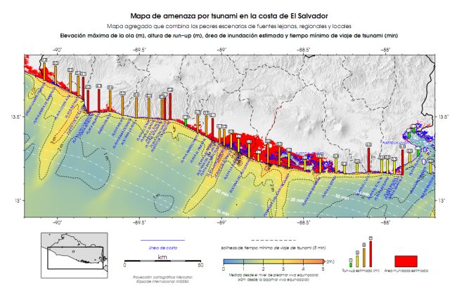
EL SALVADOR
International project aimed at assessing the danger, vulnerability and risk due to tsunamis on the coast of El Salvador in order to prepare models and evacuation plans. An important component of this project was the transfer of technology, training courses on numerically modeling the propagation of tsunamis, and workshops to disseminate the results of the project.
IDB TRUJILLO
The general goal was to provide the Platform for Emerging Sustainable Cities (ESC) and the Inter-American Development Bank (IDB) with a probabilistic assessment report on the danger of and vulnerability to floods, coastal erosion and tsunamis based on climate change projections in Trujillo (Peru). This will make it possible to identify adaptation/mitigation measures and define strategies to stop or deal with any threats facing the city.
Numerical tsunami database for the Spanish Tsunami Warning System
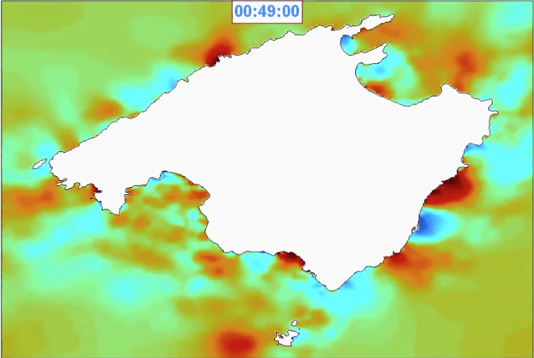
As part of the existing partnership between IHCantabria and the National Geographic Institute (IGN), a tsunami event database was developed that is now part of Spain’s tsunami warning system. This database is made up of more than 4000 numerical simulations of potential tsunami scenarios. In the event of a tsunami, the database identifies the pre-calculated event that is closest in both position and magnitude, which is used to determine the wave heights and their arrival times at Spanish coasts in advance. As a result, the IGN, which manages the alert system, has access to instantaneous data that can be used to manage the threat.
Numerical simulation of one of the tsunamis in the database, generated by an earthquake centered on the Algerian coast. Propagation of the wave to the Balearic Islands
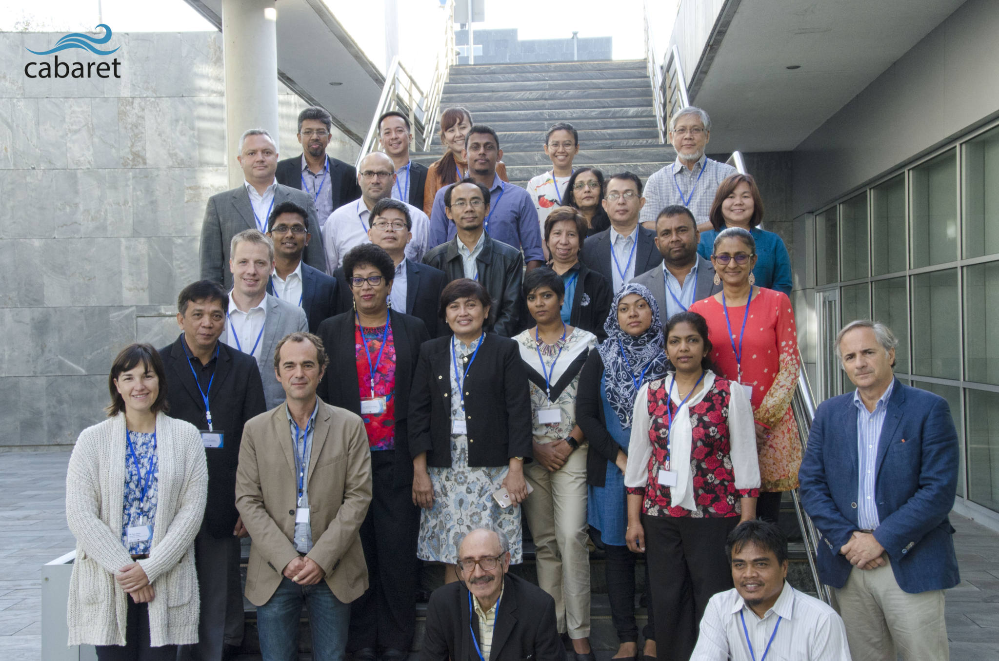
CABARET
Training in Asia for a resilient education. This project is funded by the European Union, under the Erasmus+ program, to promote regional cooperation to develop a more effective multi-risk early warning system and increase the resilience of coastal communities to disasters. It includes a strong call to education to help understand disaster risk and promote risk-based decisions and planning that takes into account disaster risks at both the local and global levels. It also encourages coordination among the existing networks and scientific research institutions at all levels and in all regions.
Learn More
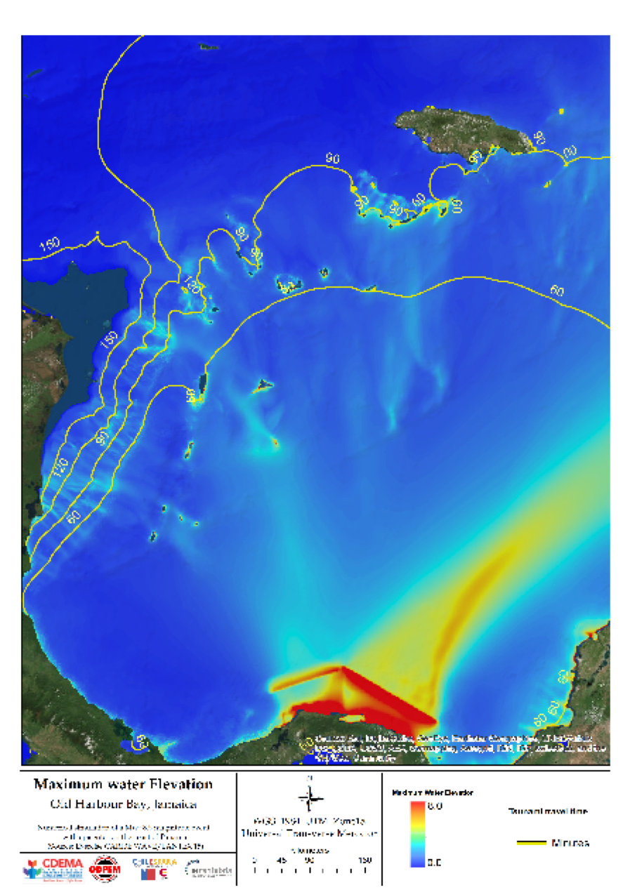
AGCI/AECID CARIBE (Jamaica)
The objective of the project was to enhance the Caribbean Disaster Emergency Management Agency (CDEMA) in tsunami and earthquake areas as part of the three-way cooperation between the Chilean Agency for International Cooperation (AGCI), the Spanish Agency for International Development Cooperation (AECID) and CDEMA. In this project, IHCantabria conducted workshops to assess the tsunami danger, vulnerability and risk to local people in the Caribbean. This resulted in tsunami flooding maps being drawn up for the pilot area of Old Harbour Bay, in Jamaica.
ASTARTE
The goal of ASTARTE is to achieve a higher level of resistance to tsunamis in the Northeast Atlantic and Mediterranean region, improve preparedness among coastal populations and, ultimately, save lives and property.
Learn More
SOFTWARE & TOOLS
Cantabria-Comcot-Tsunami-Claw model (C3)
Numerical model that is used to calculate and evaluate tsunami generation, propagation and flooding events. It is based on linear and non-linear, vertically integrated, long-period wave equations for shallow depths (NSWE).
C3 is a numerical, finite-difference model that has been validated and applied to different historical tsunami events (Indonesia-2004, Chile-2010, Japan-2011 among others) and in several projects in El Salvador, Chile, Jamaica, Oman, Spain, and other countries.
The output of C3 is the variables that define the tsunami in both deep waters and in coastal environments: wave height, travel time, depth of the sheet of water on the ground, risk of being swept away, etc.
IHTSUSY
To support these warning systems, IHCantabria has created the IH Tsunami Simulation System (IHTSUSY), a real-time tsunami simulation system that is used to determine fundamental data on how tsunamis propagate around the world, their time of arrival at any point on the coast or to estimate their flooding potential.
The results are distributed through a free mobile application, thus enhancing IHCantabria’s commitment to those most vulnerable to natural disasters. In addition, pre-computed databases are formulated to support the warning system (Oman, IGN).
![]()
LET’S TALK.
Would you like to know how we can help you?
Send us a message. We will get back to you as soon as possible
LET’S TALK.
Would you like to know how we can help you?
Send us a message. We will get back to you as soon as possible

iñigo aniel-quiroga
Researcher || Expert in Tsunamis

Ignacio Aguirre Ayerbe
Researcher || Expert in Risk Management
We advise you that your personal data will be processed by FUNDACIÓN INSTITUTO HIDRÁULICA AMBIENTAL DE CANTABRIA, in order to manage your request and maintain professional and commercial relations with you. Your data will not be transferred to third parties. This data treatment is necessary to attend your request. Your data will be kept until you unsubscribe from the service and/or after a reasonable time has passed since we attended to your request. You can exercise your rights of access, rectification, cancellation, opposition, portability and limitation of the processing of your data by contacting the FUNDACIÓN INSTITUTO HIDRÁULICA AMBIENTAL DE CANTABRIA, PCTCAN C/ISABEL TORRES, 15, 39011 SANTANDER (CANTABRIA), or rgpdihcantabria@unican.es with a copy of your ID card duly accrediting your identity. In any situation, you have the right to file a complaint with the Spanish Data Protection Agency (AEPD)