


Geographical Information Systems (GIS)
The “where” factor is fundamental in the disciplines of Earth sciences. The IH-IT Lab is immersed in the field of geographic information systems (GIS), which allows to collect, manage and analyze geospatial data to obtain patterns and relationships, helping users make smarter decisions.
At IHCantabria’s laboratory of information technology and supercomputing (IH-IT Lab), we undertake spatial analysis and geographic data management with the latest geospatial technologies (e.g. GIS, databases, visualization). In addition, at IH-IT Lab we carry out software development of geospatial solutions (Web, Desktop and mobile). Both approaches have the result of facilitating the analysis of environmental phenomena in which location is a fundamental factor.
AREAS OF EXPERTISE
GIS applied to coastal and river flood risk analysis
GIS applied to integrated coastal zone management
GIS applied to integrated river basin management
GIS applied to environmental management and planning
GIS applied to environmental impact assessment
GIS applied to ecosystem conservation (Natura 2000 Network)
PARTNERSHIPS
The IH-IT Lab has carried out the management and automation of GIS analysis processes of a large number of national and international projects, which include the following:
- Regional Study of Climate Change in the Coasts of Latin America and the Caribbean (LAC) financed by the Economic Commission for Latin America and the Caribbean (ECLAC) and the study of Climate Change in the Spanish coasts, financed by the Ministry of the Environment. The results are accessible at http://c3a.ihcantabria.com and http://c3e.ihcantabria.es
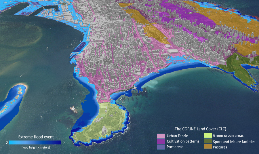
- Studies of urban development, natural risks and climate change within the initiative of Emerging and Sustainable Cities (ESCI) of the Inter-American Development Bank (IDB), applied to cities such as: Trujillo (Peru), Santa Ana (El Salvador), Port of Spain (Trinidad and Tobago), Quetzaltenango (Guatemala), Campeche (Mexico), Xalapa (Mexico), Tegucigalpa (Honduras), Santiago de los Caballeros (Dominican Republic) and Cumaná (Venezuela), among others.
RELEVANT PROJECTS

EFFECTS OF CLIMATE CHANGE ON THE COASTS OF LATIN AMERICA AND THE CARIBBEAN – C3A
Includes a study of approximately 72,182 km of coastline that analyzed the changes identified in coastal dynamics, the influence of climate variability, various sources of information on the vulnerability of the coasts (physical and socioeconomic environment), the physical layout of the coast and foreseeable impacts and risks.
Learn More
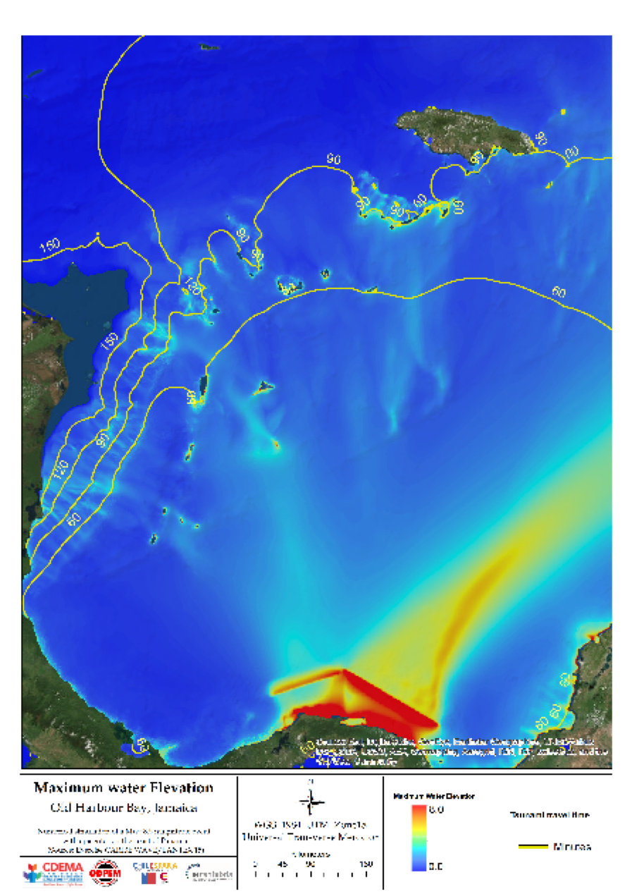
AGCI/AECID CARIBE (Jamaica)
The objective of the project was to enhance the Caribbean Disaster Emergency Management Agency (CDEMA) in tsunami and earthquake areas as part of the three-way cooperation between the Chilean Agency for International Cooperation (AGCI), the Spanish Agency for International Development Cooperation (AECID) and CDEMA. In this project, IHCantabria conducted workshops to assess the tsunami danger, vulnerability and risk to local people in the Caribbean. This resulted in tsunami flooding maps being drawn up for the pilot area of Old Harbour Bay, in Jamaica.
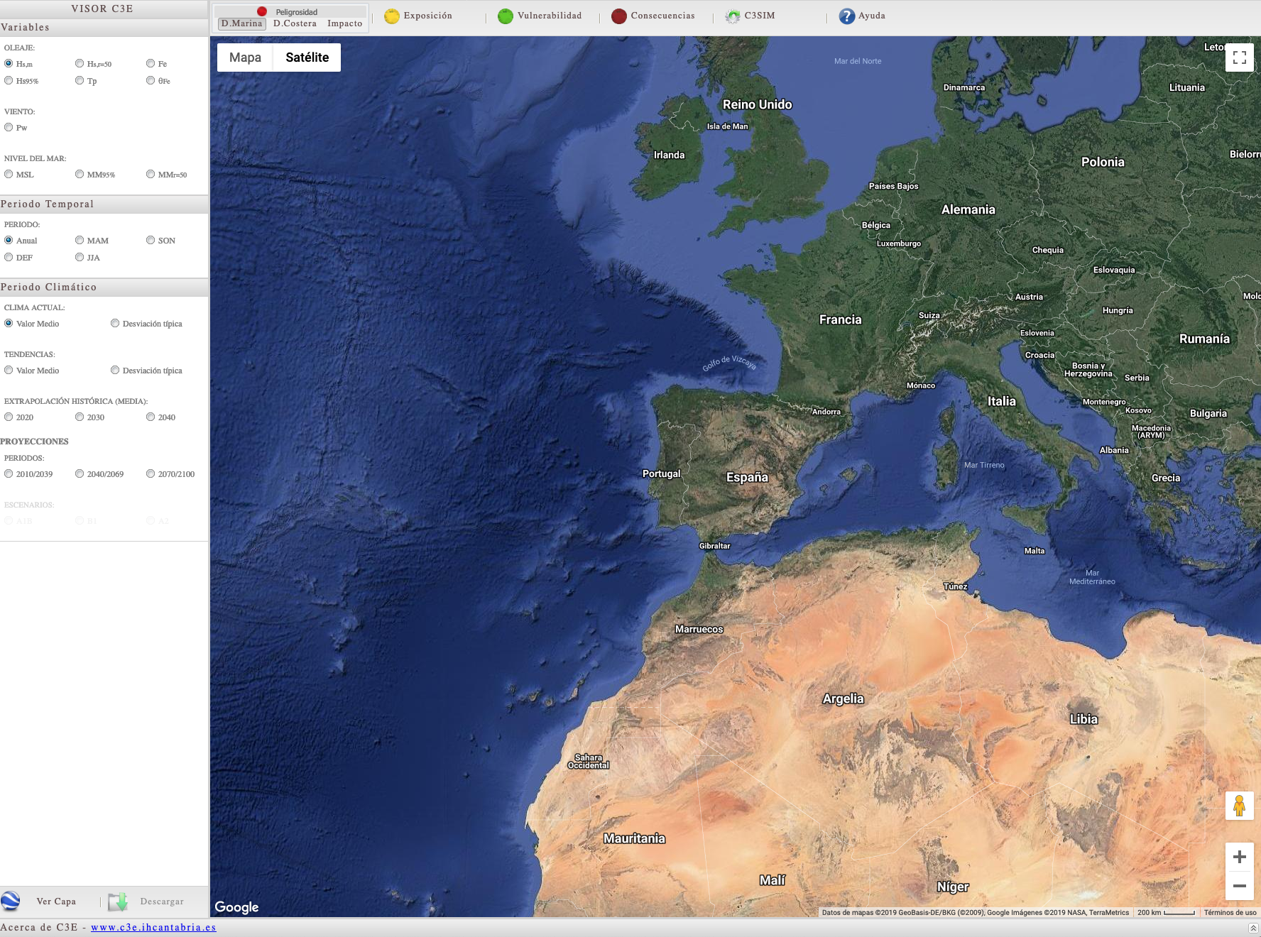
CLIMATE CHANGE ON THE SPANISH COAST – C3E.
Project financed by the MAGRAMA (Ministry of Agriculture, Food and the Environment), conducted as part of the PNACC (National Plan to Adapt to Climate Change), where the potential impacts of climate change on some of the most significant components on the Spanish coast were evaluated. The results of the project provided the basis for preparing the “Strategy to adapt the coast to the effects of climate change”, in accordance with the provisions of Law 2/2013 of 29 May, on the protection and sustainable use of the coast and amending Law 22/1988, of 28 July, on Coasts.
Learn More
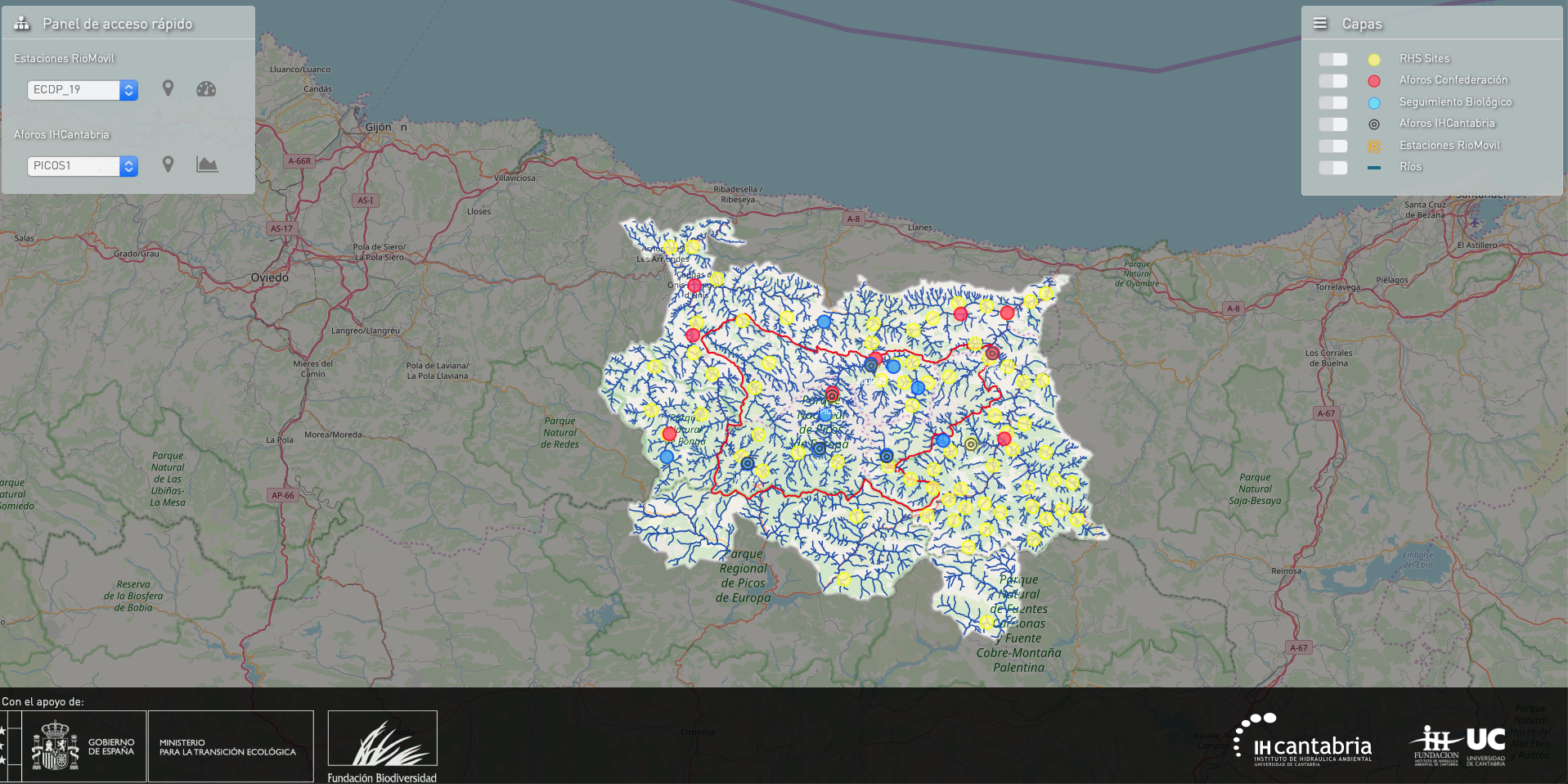
Monitoring the effects of global change in European Peaks National Park (PNPE)
The assessment of the effects of global change on aquatic ecosystems of the national park started in 2012 and continued with several projects (CENTINELA, BIOGLOB and MONITOREA) providing a long term monitoring program. This program is essential to unravel the effects of global change (such as land use and changing climate conditions) on the aquatic ecosystems of European Peaks National Park.
Know more
Access the Collected Data
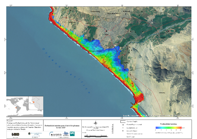
idb trujillo
The general goal was to provide the Platform for Emerging Sustainable Cities (ESC) and the Inter-American Development Bank (IDB) with a probabilistic assessment report on the danger of and vulnerability to floods, coastal erosion and tsunamis based on climate change projections in Trujillo (Peru). This will make it possible to identify adaptation/mitigation measures and define strategies to stop or deal with any threats facing the city.

ICZM PLAN FOR QATAR
Qatar’s Integrated Coastal Zone Management (ICZM) Plan aims to improve the management of coastal resources and promote the sustainable development of the coast of Qatar. The Plan lays out a common vision for coastal management and development in Qatar, and establishes the strategic and operational objectives that will guide the activities to be carried out on the coast in coming years.
LET’S TALK
Would you like to know how we can help you?
Send me a message. I will get back to you as soon as possible

FELIPE FERNÁNDEZ
Researcher || Senior GIS analyst